If you are looking for an iconic New Zealand road trip, they don’t get much more iconic than the drive from Christchurch to Greymouth on the South Island. What makes this drive so iconic we hear you say? Well, in addition to the amazing scenery along the route, this drive is perhaps most famous for the section that is known as Arthur’s Pass.
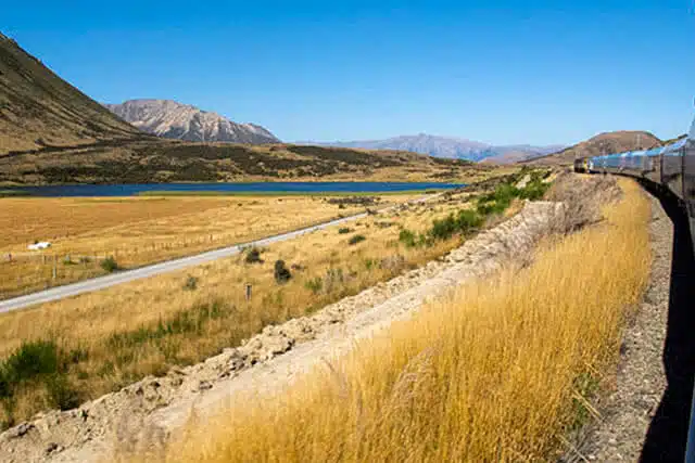
Whilst a lot of people choose to take the spectacular and very scenic train journey from Christchurch to Greymouth, we don’t think there are many better drives in the whole country and there is nothing better than cruising along, your favourite playlist blasting out, enjoying the spectacular South Island in all its glory.
History of Arthur’s Pass
Arthur’s Pass has a long history dating back to the time of the Gold Rush in the 1860s.
The township and the pass take their names after Arthur Dudley Dobson who was recruited to help to find a pass from Canterbury over the Southern Alps to the West Coast. Also recruited to find a suitable pass was Arthur’s brother, Edward Dobson. After examining different routes, Edwards conceded that “Arthur’s” pass was by far the most suitable for a direct crossing.
Prior to this, the pass had been known as Camping Flat and Bealey Flats.
Along with the road, construction of the Otira Tunnel and railway line from Christchurch to Greymouth commenced in 1908, reaching Arthur’s Pass Township in 1914 and eventually completing in 1923. The TranzAlpine passenger train that runs on the line today is widely regarded as one of the most scenic railways journeys in the world.
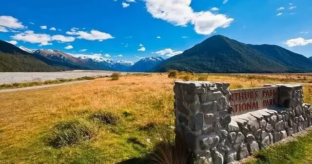
National Park
In 1929, the Arthur’s Pass National Park was established, becoming New Zealand’s third National Park at the time. An earthquake in the same year meant that the road to the West Coast was cut off for many months, with damage also sustained to the railway line. Since then, however, the National Park has gone from strength to strength and it is seen as a rugged destination with backcountry tracks and limited facilities. It is a great opportunity for people to go back to nature and explore this mountainous and stunning park.
Things to do in Arthur’s Pass
Whilst the drive itself is part of the adventure, don’t just look at this as a way of getting from Christchurch to Greymouth or the east to the West Coast. Along the route, you will discover plenty of amazing viewing points so make sure you have your camera at the ready.
Arthur’s Pass Village is located at the summit of the pass and is a great place to base yourself for exploring the area. Arthur’s Pass is more formally known as SH73 and as you make the climb to the highest point which sits at 739m above sea level, you will come across Arthur’s Pass township.
Here are five of the best things to do when visiting or travelling through Arthur’s Pass.
5 of the best things to do in Arthur’s Pass
1. Walking
There are a couple of awesome walking tracks that can be accessed from the Arthur’s Pass village and if you have the time as you make the trip across the Southern Alps, we definitely recommend stretching your legs.
The Arthur’s Pass Walking Track
Length: 6.8km
Duration: 2-3 hours
Difficulty: Easy
This is one of the most popular activities for people stopping in at Arthur’s Pass township. The great thing about the walking track is that you don’t need to do it all. Many people choose to walk from the village to the Dobson Memorial at Arthur’s Pass summit. The hike has a gradual incline and is relatively easy yet rewarding.
Avalanche Peak Hike
Length: 9.2km (return)
Duration: 4-6 hours
Difficulty: Moderate – Difficult
View this post on Instagram
For those looking for a more challenging walk, the Avalanche Peak track begins near the visitor’s centre and climbs steeply into the lush forest slopes. It’s not for the faint-hearted, however. This is a moderate to difficult hike but if you are an experienced walker and you want to experience some amazing views including waterfalls, mountain tops and clear flowing streams, then you will be well rewarded.
2. Waterfalls
With Arthur’s Peak sitting at 739m, as you can imagine, this means there is no shortage of waterfalls along the route. Some you will see out of the car window as you drive along, however, there are a couple that you should park up and go and explore on foot – you will not be disappointed.
Devil’s Punchbowl Waterfall
View this post on Instagram
This is arguably the most spectacular of the waterfalls along Arthur’s Pass. At 131m, this huge waterfall plunges down a sheer faced mountain slope in quite spectacular fashion. There is a wooden track that leads to the base of the falls and a viewing platform. If you decide to take on the Avalanche Peak hike, you will come across these spectacular falls.
Bridal Veil Falls
Another well-known waterfall along the route is the Bridal Veil Falls. It’s not quite as impressive as the Devil’s Punchbowl, however, there is a lovely 40-minute walk to reach the viewing platform. If you are researching a trip to these falls, don’t mistake them with another waterfall of the same name that is located on the North Island.
3. Castle Hill Limestone Boulders
View this post on Instagram
Lord of the Rings Fan alert! Not only are the Castle Hill limestone boulders an amazing place to visit, but they are also famous as one of the filming locations used in the LoTR movies. Located around 50kms from Arthur’s Pass township, the limestone boulders were used in the scene in the Fellowship of the Rings when the group take a rest in the rocky plateau en route to the Misty Mountains.
Popular with photographers as well as LoTR fans, the limestone formations sit atop a hill just off the highway and are well signposted. You can learn more about the Castle Hill limestone boulders here.
4. Cave Stream Scenic Reserve
View this post on Instagram
If you are looking for something a bit different on your Arthur’s Pass trip, make sure you check out the Cave Stream Scenic Reserve. There are a couple of tracks that will take you to the entrance to the cave and these are both nice walking tracks that will take you through limestone-formed landscapes.
For the more adventurous, you can walk through the caves, but this should only be done if you have the right equipment and you are well prepared. The cave passage meanders and twists in pitch darkness for 594 m between the two entrances. There is a 3 m waterfall at the inlet end. If care is taken, fit, inexperienced cavers can go through. You can read more about the cave walk on the DOC website.
5. Otira Viaduct Lookout
View this post on Instagram
One of the most spectacular features of Arthur’s Pass is the Otira Viaduct – one of the most photographed sections of road in New Zealand. Depending on which way you are going, you may have already passed over the viaduct, however, there is a very good lookout spot that provides stunning views of the mountain valley and bridge looking towards the West Coast.
Arthur’s Pass FAQs
We hope we have given you plenty of good reasons to add a roadie from Christchurch to Greymouth or vice versa to your bucket list but if not, here are some of the most frequently asked questions on Google about Arthur’s Pass which may just seal the deal.
Can you drive through Arthur’s Pass?
Of course! This post has been dedicated to the awesome drive through Arthur’s Pass and we definitely recommend you add it to your list of places to visit. Most people choose to drive from Christchurch to Greymouth or vice versa and the drive will take you around 3 hours and 20 minutes and is 241 km via Arthur’s Pass. You can pick up a car rental at Christchurch Airport and hit the road in no time.
How long is Arthur’s Pass?
Located 140 km from Christchurch and 95 km from Greymouth, the pass comprises part of a saddle between the valleys of the Otira River (a tributary of the Taramakau River in the west) and of the Bealey River (in the east).
How high is Arthur’s Pass?
739m
Can you drive through Artur’s Pass in winter?
The road does open during the winter months, however, heavy snowfall can lead to localized road closures which are well signposted. No matter the conditions, between May and October, it is highly recommended that all vehicles should carry correctly fitting snow chains for your vehicle and know how to fit them. If you are renting a car from GO during this period, snow chains can be hired and we will show you how to fit them before you set off.
Why is it called Arthur’s Pass?
It was crossed for the first time by Europeans in 1864 and named after the surveyor Arthur Dobson. In 1863 Thomas Cass, the Chief Surveyor for Canterbury asked Arthur Dobson to look for a pass between the Waimakariri River basin and a valley running to the west coast.
When was Arthur’s Pass built?
Arthur’s Pass was established in 1929 and was New Zealand’s third national park and the first one in the South Island.
Round-Up
Arthur’s Pass is one of the most spectacular driving routes in New Zealand and we highly recommend you factor it into your next South Island road trip. It’s definitely not all about the drive though, and we hope you allow some time to investigate the amazing walks, stunning waterfall and pretty cool limestone features along the way. If you are looking to explore the wider Canterbury region, make sure you check out our welcome to Canterbury guide for lots of great tips on things to see and do in Canterbury.